Tesseroids: forward modeling in spherical coordinates

A collection of command-line programs for modeling the gravitational potential, acceleration, and gradient tensor. Tesseroids supports models and computation grids in Cartesian and spherical coordinates.
Developed by Leonardo Uieda in cooperation with Carla Braitenberg.
Official site: http://tesseroids.leouieda.com
License: BSD 3-clause
Source code: https://github.com/leouieda/tesseroids
Latest release: v1.2.1 (doi:10.5281/zenodo.582366)
Note
Tesseroids is research software. Please consider citing it in your publications if you use it for your research.
Warning
See the list of known issues for things you should be aware of.
The geometric element used in the modeling processes is a spherical prism, also called a tesseroid. Tesseroids also contains programs for modeling using right rectangular prisms, both in Cartesian and spherical coordinates.
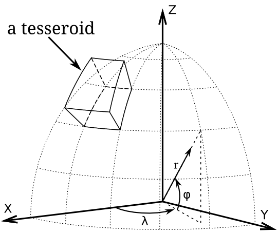
View of a tesseroid (spherical prism) in a geocentric coordinate system. Original image (licensed CC-BY) at doi:10.6084/m9.figshare.1495521.
Getting started
Take a look at the examples in the Cookbook. They contain scripts that run Tesseroids and some Python code to plot the results.
If you’re the kind of person who likes to see the equations (who doesn’t?), see the Theoretical background and the references cited there.
For a more detailed description of the software, options, and conventions used, see the usage instructions.
Also, all programs accept the -h flag to print the instructions for using
that particular program. For example:
$ tessgrd -h
Usage: tessgrd [PARAMS] [OPTIONS]

Make a regular grid of points.

All units either SI or degrees!

Output:
  Printed to standard output (stdout) in the format:
    lon1    lat1    height
    lon2    lat1    height
    ...     ...     ...
    lonNLON lat1    height
    lon1    lat2    height
    ...     ...     ...
    ...     ...     ...
    lonNLON latNLAT height

  * Comments about the provenance of the data are inserted into
    the top of the output

Parameters:
  -r           W/E/S/N: Bounding region of the grid.
  -b           NLON/NLAT: Number of grid points in the
               longitudinal and latitudinal directions.
  -z           HEIGHT: Height of the grid with respect to the
               mean Earth radius.
  -h           Print instructions.
  --version    Print version and license information.

Options:
  -v           Enable verbose printing to stderr.
  -lFILENAME   Print log messages to file FILENAME.

Part of the Tesseroids package.
Project site: <http://fatiando.org/software/tesseroids>
Report bugs at: <http://code.google.com/p/tesseroids/issues/list>
Getting help
Write an e-mail to Leonardo Uieda, or tweet, or Google Hangout. Even better, submit a bug report/feature request/question to the Github issue tracker.
Contents
- Citing
- Known issues
- Changelog
- Installing
- Releases
- Theorerical background
- Using Tesseroids
- A note about heights and units
- Getting help information
- Computing the gravitational effect of a tesseroid
- The -a flag
- Verbose and logging to files
- Comments and provenance information
- Generating regular grids
- Automatic model generation
- Calculating the total mass of a model
- Computing the effect of rectangular prisms in Cartesian coordinates
- Piping
- Cookbook
- Calculate the gravity gradient tensor from a DEM
- Simple prism model in Cartesian coordinates
- Simple tesseroid model
- Convert a tesseroid model to prisms and calculate in spherical coordinates
- Convert a tesseroid model to prisms and calculate in Cartesian coordinates
- Using tesslayers to make a tesseroid model of a stack of layers
- License